 Nederlands
 Dansk
Dansk Österreichisch
 Po Polsku


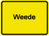
Community Weede
Weede is also interesting for new residents through its favourable location in regards traffic
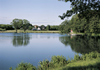
The community terrain of the community Weede is situated east of Bad Segeberg and comprises of 1.640ha. The villages Weede, Steinbek, Mielsdorf and Söhren, with its around 900 inhabitants belong to the community.
The name Weede stems from the middle-German Weede-Holz (wood). The community was first recorded in the year 1447. Due to the favourable location in regards traffic to Bad Segeberg the village became also interesting for new residents, which in turn lead to the construction of the housing estate "Rössra".
The name of the village Mielsdorf derives probably from a person's name. It is not possible to establish whether Mielsdorf was founded already at Slavic times or at the time of the German colonisation after 1137.
The village Steinbek was first recorded in 1249. The village name is identical to the stream Steinbach, Lower German: Steenbeke. The village belongs to the so-called forest villages of the former borough Traventhal and originated as a distinctly ribbon-built village.
The former mayor of the community Weede, Werner Wittern, who stems from Steinbek, was also the 1st head official of the borough Segeberg-Land in its present form.
The village name Söhren stems from Lower German and means as much as 'dry landscape', which indicates that the village originated on warm dry soil protected by surrounding woods.
Altogether the community enjoys a lively club life with its centre in the youth and sports home located in Weede, it's also the home of SV Weede.


")


